The Himalayan Ranges and their Importance
1. Basic introduction about the Himalayas
The Himalayas not only form a physical barrier between the Indian subcontinent and the Central and East Asian countries but also a climatic, drainage and cultural divide.
The Himalayas are young and fold mountains. They are spread over a distance of nearly 2400 km and form an arc. Their width varies from 400 Km in Kashmir to 150 Km in Arunachal Pradesh. The altitudinal variation is greater in the eastern half in comparison to the western half.
2. Longitudinal divisions of the Himalayas
The Himalayas are made up of three parallel mountain ranges- Greater Himalayas, Middle Himalayas and Shiwaliks. These are described below:
2.1. Greater Himalayas/ Inner Himalayas/ The Himadri
- It is the northern-most Himalayan range.
- All prominent Himalayan peaks lie in this range. The world’s highest peak, Mt. Everest (known as Sagarmatha in Nepal) is located in this range.
- The average height of peaks in this range is 6,000 metres.
- It is the most continuous range.
- It is characterized by the presence of asymmetrical folds and hogback topography.
- Its core is made up of granite.
- Many glaciers descend from this range.
- Some of the famous passes located in this range are:
- Jammu and Kashmir- Burzil Pass, Zoji La
- Himachal Pradesh- Bara Lacha La, Shipki La
- Uttarakhand- Thaga La, Niti Pass, Lipu Lekh
- Sikkim- Nathu La, Jelep La
2.2. Himachal/ Lesser Himalayas/ Middle Himalayas
- It is located to the south of Himadri.
- It is the most rugged mountain system.
- It is mainly made up of highly compressed rocks.
- Its average width is about 50 Km.
- Its altitude ranges between 3,700 and 4,500 metres.
- Valley of Kashmir, the Kangra and Kullu Valley in Himachal Pradesh are part of this range.
- It is famous for its hill stations like Shimla, Mussoorie, Ranikhet, Nainital, Darjeeling, etc.
- Some of the important ranges of the Middle Himalayas are- Pir Panjal Range, Dhauladhar range, Mussoorie range, etc.
2.3. Shiwaliks
- It is the outermost range of the Himalayas.
- Its width varies from 10 to 50 km.
- Its altitude varies between 900 and 1100 metres.
- It is made up of unconsolidated sediments.
- Longitudinal valleys between lesser Himalaya and Shiwaliks are called Duns (Dehra Dun, Kotli Dun and Patli Dun).
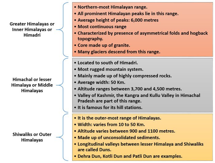
Fig.1: The Himalayan ranges
3. The Trans Himalayas
- The Trans Himalayas lies immediately north of the Great Himalayan range.
- This range is also known as the Tibetan Himalaya as a major part of it lies in Tibet.
- It stretches for a distance of about 1,000 km in the east-west direction.
- Its average altitude is 3,000 metres.
- The average width ranges between 40 km and 225 km.
- K2 (8,611 m) or Mt. Godwin Austin is the second highest peak in the world. It is the highest peak in India.
- The main ranges of the Trans Himalayas are the Zanskar range, Ladakh, Kailash and Karakoram range.
- The Kailash Range is an offshoot of the Ladakh Range. Indus originates from the slopes of the Kailash range. Mount Kailash is the highest peak here.
- The Karakorams are part of a complex of mountain ranges at the centre of Asia, including the Hindu Kush to the west, the Pamirs to the northwest, the Kunlun Mountains to the northeast, and the Himalayas to the southeast.
- Nanga Parbat lies in the Zanskar Range. The Ladakh range runs parallel to the Zanskar range.
4. Regional divisions of the Himalayas
In addition to the longitudinal divisions, the Himalayas can be divided into regional divisions demarcated by river valleys. These regional divisions are provided in the next table.
|
Part of Himalayas |
Name of the Part |
|
Part of the Himalayas located between Indus and Satluj rivers |
Punjab Himalayas |
|
Part of the Himalayas located between Satluj and Kali rivers |
Kumaon Himalayas |
|
Part of the Himalayas located between Kali and Teesta rivers |
Nepal Himalayas |
|
Part of the Himalayas located between Teesta and Dihang rivers |
Assam Himalayas |
5. The Purvachal or the Eastern hills and mountains
Brahmaputra River forms the eastern-most boundary of the Himalayas. Beyond Dihang gorge, the Himalayas curve sharply to the south. The Himalayas along the eastern boundary of India are called the Purvachal or the Eastern hills and mountains. The Purvachal is made up of Patkai hills, the Naga Hills, the Manipur hills and the Mizo hills.
|
Highest Peaks of the Himalayas |
|||
|
Peak and country |
Height (in metres) |
Peak and country |
Height (in metres) |
|
Mt. Everest (Nepal) |
8848 |
Annapurna (Nepal) |
8078 |
|
Kanchenjunga (India) |
8598 |
Nanda Devi (India) |
7817 |
|
Makalu (Nepal) |
8481 |
Kamet (India) |
7756 |
|
Dhaulagiri (Nepal) |
8172 |
Namcha Barwa (India) |
7756 |
|
Nanga Parbat (India) |
8126 |
Gurla Mandhata (Nepal) |
7728 |
6. Five subdivisions of the Himalayas
The Himalayas can also be divided into five subdivisions listed and described below.
- Kashmir or Northwestern Himalayas
- Himachal and Uttarakhand Himalayas
- Darjeeling and Sikkim Himalayas
- Arunachal Himalayas
- Eastern Hills and Mountains
6.1. Kashmir or Northwestern Himalayas
The northeastern section of Kashmir Himalayas is a cold desert located between Greater Himalayas and Karakoram ranges. Longitudinal valleys in the southeastern part of this region are called duns. For example, Jammu dun and Pathankot dun.
- Karewa formations:
- Karewa formations are found in Kashmir or Northwestern Himalayas.
- Zafran (saffron variety) is cultivated in Karewa formations.
- Karewa formations are thick deposits of glacial clay and moraines.
- Rivers of this region:
- River Indus, its tributaries like Jhelum and Chenab.
- Despite being in its youth stage in Kashmir valley, Jhelum forms meanders (a typical feature of the mature stage of the river).
- The union territory of Jammu and Kashmir’s capital, Srinagar is located on the bank of the Jhelum River.
Important Facts to Remember:
Ranges in Kashmir or Northwestern Himalayas: Karakoram, Ladakh, Zaskar and Pir Panjal (Dal Lake in Sri Nagar and Kashmir valley are located between Great Himalayas and Pir Panjal range.)
Glaciers in Kashmir or Northwestern Himalayas: Baltoro and Siachen glacier
Passes of Kashmir or Northwestern Himalayas: Zoji La on the Great Himalayas, Banihal on the Pir Panjal, Photu La on the Zaskar, Khardung La on the Ladakh range
Lakes of Kashmir or Northwestern Himalayas: Fresh lakes like Dal and Wular and saltwater lakes like Pangong Tso and Tso Moriri.
Famous pilgrimages of Kashmir or Northwestern Himalayas: Vaishno Devi, Amarnath Cave, Charar-e-Sharif
6.2. Himachal and Uttarakhand Himalayas
All three ranges of Himalayas (the Great Himalayan range, the Lesser Himalayas and the Shiwalik range) are prominent in this part. The Lesser Himalayas is locally known as Dhauladhar in Himachal Pradesh and Nagtibha in Uttarakhand. ‘Valley of flowers’ is also located in this region.
- Location of this region: Ravi in west and Ghaghara’s tributary, Kali in east
- Rivers draining this part: Tributaries of Indus (Ravi, Beas and Satluj) and tributaries of Ganga (Yamuna and Ghaghara)
- Important hill stations (located at an altitude between 1,000-2,000 m): Dharamshala, Mussoorie, Shimla, Kaosani
- Important duns of this region: Chandigarh-Kalka dun, Nalagarh dun, Dehra Dun (largest of all duns), Harike dun and the Kota dun
- Pilgrimages in this part: Gangotri, Yamunotri, Kedarnath, Badrinath and Hemkund Sahib
- Bhotias and Bugyals: Bhotias are the nomadic groups that inhabit valleys in the Great Himalayan range during winters. They migrate to Bugyals during the summer months. Bugyals are the summer grasslands in higher reaches.
6.3. Darjeeling and Sikkim Himalayas
This part of the Himalayas is famous for its fast-flowing rivers like Tista. Lepcha tribes inhabit higher reaches of this region. Darjeeling and Sikkim Himalayas are famous for scenic beauty, flora and fauna, particularly Orchids.
- Mountain peaks of this region: High Mountain peaks (For example, Kanchenjunga/Kanchengiri) and deep valleys are found in this region.
- Physical conditions and tea plantations: Due to moderate slope, thick soil cover with high organic content, well-distributed rainfall all over the year and mild winters, the British introduced tea plantations in this region.
- Shiwalik formations and duar formations: Shiwalik formations are not found in Darjeeling and Sikkim Himalayas as well as in Arunachal Himalayas. Instead of Shiwalik formations, duar formations are found in Darjeeling and Sikkim Himalayas.
6.4. Arunachal Himalayas
They spread from east of the Bhutan Himalayas to Diphu pass in the east. They are known for fast-flowing rivers, which form deep gorges. It has rugged topography.
- Important Mountain peaks of this region: Kangtu and Namcha Barwa
- Important rivers of this region: Kameng, Subansiri, Dihang, Dibang and Lohit. These are perennial rivers with the highest hydroelectric power potential in the country.
- Ethnic tribal communities inhabiting this region: Monpa, Abor, Mishmi, Nyishi and Nagas. They practice Jhumming or shifting or slash and burn cultivation.
6.5. The Eastern Hills and Mountains
These come under the Himalayan mountain system. These are low hills. Their local names are Patkai Bum, Naga Hills, Manipur hills in the north and Mizo or Lushai hills in the south. Barak is a river in Manipur and Mizoram. It is the tributary of Meghna. India’s largest natural freshwater lake, Loktak Lake, is located in Manipur. Mizoram is also called Molassis basin. It consists of soft unconsolidated deposits.
7. Importance of Himalayas
- The Himalayas prevents cold Siberian winds from entering India.
- The Himalayas acts as a source for many perennial rivers.
- The Himalayas prevent the monsoon winds of the Indian Ocean from crossing over to Northern countries and bring heavy rainfall in North and north-east India. They also cause rain in winters in India after splitting the subtropical jet streams into two.
- The Himalayas are a rich source of biodiversity and herbs and medicines.
Summary
The Himalayas: Form physical barrier, climatic, drainage and cultural divide, young and fold mountains and form an arc. Length: nearly 2400 km, Width: 400 Km in Kashmir to 150 Km in Arunachal Pradesh
Greater or Inner Himalayas or the Himadri: Northern-most Himalayan range, World’s highest peak, Mt. Everest (known as Sagarmatha in Nepal), most continuous range and characterized by the presence of asymmetrical folds and hogback topography
Himachal or Lesser Himalayas or Middle Himalayas: Located to the south of Himadri, most rugged mountain system, Valley of Kashmir, the Kangra and Kullu Valley in Himachal Pradesh
Shiwalik or Outer Himalayas: Outer-most range of Himalayas, made up of unconsolidated sediments, Longitudinal valleys between lesser Himalaya and Shiwaliks are called Duns (Dehra Dun, Kotli Dun and Patli Dun).
Regional divisions of Himalayas: Punjab Himalayas, Kumaon Himalayas, Nepal Himalayas, Assam Himalayas
The Purvachal or the Eastern hills and mountains are made up of Patkai hills, the Naga Hills, the Manipur hills and the Mizo hills.
Kashmir or Northwestern Himalayas: Longitudinal valleys called duns, cold desert, Karewa formations and Zafran (saffron variety) cultivation, River Indus, its tributaries like Jhelum and Chenab flow through this region
Himachal and Uttarakhand Himalayas: Valley of flowers, All three ranges of Himalayas prominent, hill stations like Dharamshala, Mussoorie, duns like Dehra Dun (largest of all duns), Harike dun, Bhotia’s (nomadic group) and Bugyals (summer grasslands)
Darjeeling and Sikkim Himalayas: Lepcha tribes, famous for Orchids, Kanchenjunga, tea plantations, Shiwalik formations absent, duar formations present
Arunachal Himalayas: Fast-flowing rivers, rugged topography, mountains like Kangtu and Namcha Barwa, perennial rivers with highest hydro-electric power potential, Jhumming or shifting or slash and burn cultivation
Frequently Asked Questions (FAQs) about The Himalayan Mountain Ranges
Which is the northern most range of the Himalayas?
Which Himalayan range is the most rugged mountain system and mainly made up of highly compressed rocks?
What is the name of outer-most range of the Himalayas?
World’s highest peak, Mt. Everest, is located in which range of Himalayas?
What is the name of part of Himalayas located between Satluj and Kali rivers?
Asymmetrical folds and hogback topography are characteristic features of which Himalayan range?
What is the name of second-highest peak of Himalayas located in India?
Which crop is cultivated in Karewa formations found in Kashmir or Northwestern Himalayas?
What is the name of summer grasslands found in higher reaches of Himachal and Uttarakhand Himalayas?
Where is India’s largest natural freshwater lake, Loktak Lake located?
Happy February get 35% Off
Use Coupon code FEB26


Share Blog
 Latest
Daily Current Affairs

New Launch
MONTHLYCURRENT AFFAIRS
FEBRUARY 2026
SAGA
Latest Current Affairs

Daily Current Affairs and GK | 12 and 13 April 2026
Read More
Daily Current Affairs and GK | 11 April 2026
Read More
Daily Current Affairs and GK | 10 April 2026
Read More
Daily Current Affairs and GK | 9 April 2026
Read More
Daily Current Affairs and GK | 8 April 2026
Read More

Comments