India: Size and Location Class 9 Notes NCERT and MCQs
 21-03-2024
 18:27 PM IST
 Priyanka Chaudhary
This chapter discusses the physical extents of India and some necessary facts related to her location. This will help you know about the physical boundaries of India and its neighbouring countries. This chapter will give you a clear picture regarding the location of India.
Physical Extents of India
- India lies entirely in Northern and Eastern Hemisphere.
- Latitudinal extent (mainland): 8°4'N - 37°6'N (3214 km)
- Longitudinal extent: 68°7'E - 97°25'E (2933 km)
- Area: 3.28 million square km (It is 2.4% of total geographical area of the world).
- The southernmost point of the Indian Union– ‘Indira Point’ (got submerged under the sea water in 2004 during the Tsunami).
- The Tropic of Cancer (23° 30'N) divides the country into almost two equal parts. It passes through 8 states- Gujarat, Rajasthan, Madhya Pradesh, Chhattisgarh, Jharkhand, West Bengal, Tripura and Mizoram.
- To the southeast and southwest of the mainland, lie the Andaman and Nicobar Islands and the Lakshadweep islands in Bay of Bengal and Arabian Sea respectively.
- India is the seventh largest country of the world in terms of area and second largest in terms of population.
- Total land boundary: 15,200 km
- Total length of coastline (including islands): 7,516.6 km (As per NCERT book)
- As per Handbook on Fisheries Statistics 2020, India has a coastline of 8118 km, which passes through 9 coastal states and 4 union territories.
| India’s coastal states/UTs and coastal length (Figures from Handbook on Fisheries Statistics, 2020) | ||
| 1. | Andaman & Nicobar | 1912km |
| 2. | Andhra Pradesh | 974km |
| 3. | Dadra & Nagar Haveli and Daman and Diu | 27km |
| 4. | Goa | 104km |
| 5. | Gujarat | 1600km |
| 6. | Karnataka | 300km |
| 7. | Kerala | 590km |
| 8. | Lakshadweep | 132km |
| 9. | Maharashtra | 720km |
| 10. | Odisha | 480km |
| 11. | Puducherry | 45km |
| 12. | Tamil Nadu | 1076km |
| 13. | West Bengal | 158km |
|
| Total | 8,118km |
- India is bounded by the young fold mountains in the northwest, north and northeast.
- South of about 22°N latitude, it begins to taper, and extends towards the Indian Ocean, dividing it into two seas, the Arabian Sea on the west and the Bay of Bengal on its east.
- The latitudinal and longitudinal extent of the mainland is about 30°, even then, the east-west extent appears to be smaller than the north-south extent.
- The time along the Standard Meridian of India (82°30'E) passing through Mirzapur (in Uttar Pradesh) is taken as the standard time for the whole country.
- The latitudinal extent influences the duration of day and night, as one moves from south to north.
India and the World
- India is a southward extension of the Asian continent and is located centrally between East and West Asia.
- The trans Indian Ocean routes, which connect the countries of Europe in the West and the countries of East Asia, provide a strategic central location to India.
- India has the longest coastline in the Indian Ocean and is the only country in the world with an ocean named after her.
- India’s contacts with the World have continued through ages but her relationships through the land routes are much older than her maritime contacts.
- The various passes across the mountains in the north have provided passages to the ancient travelers thus contributing in the exchange of ideas and commodities.
- While the philosophy of Upanishads, Panchatantra stories, Indian numerals and decimal system, spices, muslin, etc., reached from India to other parts of the world, India was also influenced by Greek sculpture and West Asian style of architecture.
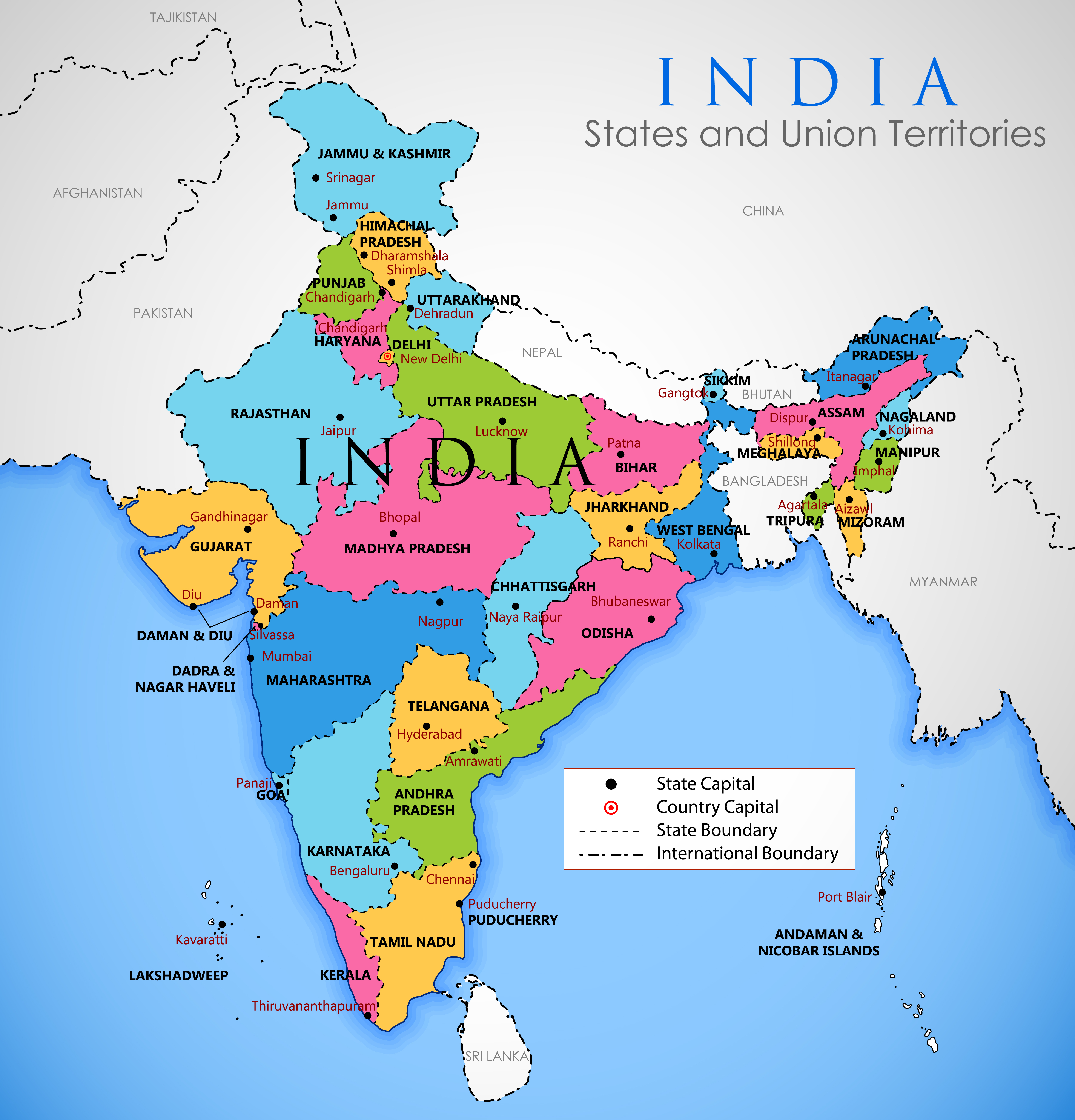
Countries sharing border with India
- India shares its land boundaries with Pakistan and Afghanistan in the northwest, China (Tibet), Nepal and Bhutan in the north and Myanmar and Bangladesh in the east.
| Neighboring Country | Indian states sharing border |
| Nepal | Uttar Pradesh, Uttarakhand, Bihar, West Bengal and Sikkim |
| Bhutan | Assam, Arunachal Pradesh, West Bengal and Sikkim |
| China | Himachal Pradesh, Uttarakhand, Arunachal Pradesh, Jammu and Kashmir and Sikkim |
| Myanmar | Arunachal Pradesh, Nagaland, Manipur and Mizoram |
| Pakistan | Punjab, Rajasthan, Gujarat and Jammu & Kashmir |
| Bangladesh | Assam, West Bengal, Mizoram, Meghalaya, and Tripura |
- Our southern neighbors across the sea consist of the two island countries, namely Sri Lanka and Maldives.
- Sri Lanka is separated from India by a narrow channel of sea formed by the Palk Strait and the Gulf of Mannar.
NOTE:
A Strait is a narrow passage of water that connects two seas or separates two landmasses.
A Gulf is a large inlet from the ocean into the landmass. Its opening is narrower than a bay.
- Maldives Islands are situated to the south of the Lakshadweep Islands.
Need to Know Facts
- School Bhuvan is a portal providing map-based learning to bring awareness among the students about the country’s natural resources, environment and their role in sustainable development. It is an initiative of Bhuvan — NRSC/ISRO based on NCERT syllabus.
- The Suez Canal was opened in 1869, thereby reducing India’s distance to Europe by 7,000 km.
MCQs based on NCERT Class 9 Geography Chapter 1:India: Size and Location
1. The Tropic of Cancer does not pass through
(a) Rajasthan
(b) Odisha
(c) Chhattisgarh
(d) Tripura
Ans. b
Explanation:
The Tropic of Cancer (23° 30'N) passes through 8 Indian states- Gujarat, Rajasthan, Madhya Pradesh, Chhattisgarh, Jharkhand, West Bengal, Tripura and Mizoram. It does not pass through Odisha.
2. The easternmost longitude of India is
(a) 97° 25' E
(b) 68° 7' E
(c) 77° 6' E
(d) 82° 32' E
Ans. a
Explanation:
The longitudinal extent of Indian mainland is 68° 7' E and 97° 25' E. So, the easternmost longitude of India is 97° 25' E.
3. Uttarakhand, Uttar Pradesh, Bihar, West Bengal and Sikkim have common frontiers with
(a) China
(b) Bhutan
(c) Nepal
(d) Myanmar
Ans. c
Explanation:
Nepal shares its border with five Indian states namely Uttar Pradesh, Uttarakhand, Bihar, West Bengal and Sikkim. Bhutan shares its border with Assam, Arunachal Pradesh, West Bengal and Sikkim.
4. Which of the following countries does not share a land boundary with India?
(a) Bhutan
(b) Tajikistan
(c) Bangladesh
(d) Nepal
Ans. b
Explanation:
Bhutan, Bangladesh, Afghanistan, Pakistan, Myanmar, China and Nepal share their land boundary with India. Tajikistan is a country that lies in Central Asia.
Frequently Asked Questions (FAQs) about India: Size and Location
What is the latitudinal extent of India?
Which island group of India lies to its south-east?
Which strait separates Sri Lanka from India?
Share Blog
 Latest

Comments