Physical Features of India Class 9 Notes NCERT and MCQs
 23-08-2023
 17:14 PM IST
 Priyanka Chaudhary
This chapter discusses the six physiographic features of India including mountains, plateaus, plains, islands, coastal plains, and deserts.
The Himalayan Mountains
- These are young fold mountains and run in a west-east direction from the Indus to the Brahmaputra.
- The Himalayas represent the loftiest and one of the most rugged mountain barriers of the world.
- They form an arc, which covers a distance of about 2,400 km and their width varies from 400 km in Kashmir to 150 km in Arunachal Pradesh.
- The Western Himalayas have more altitude than the Eastern Himalayas.
- The Himalayas consists of three parallel ranges in their longitudinal extent:
Great Himalayas
The northern-most range is known as the Great or Inner Himalayas or the Himadri.
- It is the most continuous range consisting of the loftiest peaks with an average height of 6,000 m and contains all prominent Himalayan peaks.
- The highest peaks found in the range are Mt Everest (Nepal), Kanchenjunga (India) and Mt Makalu (Nepal).
- The folds of the Great Himalayas are asymmetrical in nature. The core of this part of the Himalayas is composed of granite.
- It is perennially snow bound, and a number of glaciers descend from this range.
Himachal or Less Himalaya
The range lying to the south of the Himadri forms the most rugged mountain system and is known as Himachal or lesser Himalaya.
- The ranges are mainly composed of highly compressed and altered rocks.
- The altitude varies between 3,700 and 4,500 m and the average width is 50 Km.
- While the Pir Panjal range forms the longest and the most important range, the Dhaula Dhar and the Mahabharat ranges are also prominent ones.
- This range consists of the famous valley of Kashmir, the Kangra and Kullu Valley in Himachal Pradesh and is well-known for its hill stations.
Outer Himalayas
The outer-most range of the Himalayas is called the Shiwaliks.
- They extend over a width of 10-50 Km and have an altitude varying between 900 and 1100 m.
- These ranges are composed of unconsolidated sediments brought down by rivers from the main Himalayan ranges located farther north.
- The longitudinal valley lying between lesser Himalayas and the Shiwaliks is known as Duns. Dehra Dun, Kotli Dun and Patli Dun are some of the well-known Duns.
Some of the highest peaks of the Himalayas
|
Peak |
Country |
Height (in metres) |
|
Mt. Everest |
Nepal |
8848 |
|
Kanchenjunga |
India |
8598 |
|
Makalu |
Nepal |
8481 |
|
Dhaulagiri |
Nepal |
8172 |
|
Nanga Parbat |
India |
8126 |
|
Annapurna |
Nepal |
8078 |
|
Nanda Devi |
India |
7817 |
|
Kamet |
India |
7756 |
|
Namcha Barwa |
India |
7756 |
|
Gurla Mandhata |
Nepal |
7728 |
East to West division of Himalayas
The Himalayas have also been divided on the basis of regions from west to east which has been demarcated by river valleys.
- The part of Himalayas lying between Indus and Satluj has been traditionally known as Punjab Himalaya but it is also known regionally as Kashmir and Himachal Himalaya from west to east respectively.
- The part of the Himalayas lying between Satluj and Kali rivers is known as Kumaon Himalayas.
- The Kali and Teesta rivers demarcate the Nepal Himalayas and the part lying between Teesta and Dihang rivers is known as Assam Himalayas.
- Beyond the Dihang gorge, the Himalayas bend sharply to the south and spread along the eastern boundary of India. They are known as the Purvachal or the Eastern hills and mountains.
- The Purvachal comprises the Patkai hills, the Naga hills, the Manipur hills and the Mizo hills.
- These hills running through the north-eastern states are mostly composed of strong sandstones, which are sedimentary rocks. Covered with dense forests, they mostly run as parallel ranges and valleys.
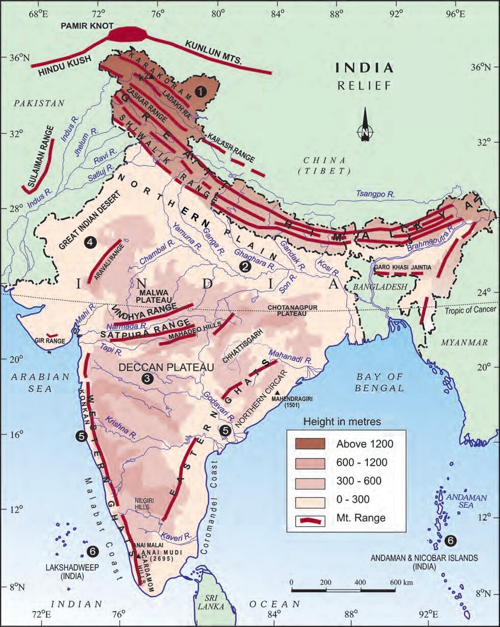
Fig.1: Physical features of India
(Source: NCERT Class 9 Contemporary India book)
The Northern Plain
- The northern plain has been formed by the interplay of the three major river systems, namely — the Indus, the Ganga and the Brahmaputra along with their tributaries.
- The deposition of alluvium in a vast basin lying at the foothills of the Himalayas over millions of years, formed this fertile plain.
- It spreads over an area of 7 lakh sq. km, is about 2400 km long and 240 to 320 km broad, and is a densely populated physiographic division.
- With a rich soil cover combined with adequate water supply and favourable climate, it is agriculturally a productive part of India.
- The Northern Plain is broadly divided into three sections:
- The Western part of the Northern Plain is referred to as the Punjab Plains.
- Formed by the Indus and its tributaries, the larger part of this plain lies in Pakistan.
- This section of the plain is dominated by the doabs (‘Doab’ is made up of two words - ‘do’ meaning two and ‘ab’ meaning water.).
- The Ganga plain extends between Ghaggar and Teesta rivers.
- It is spread over the states of North India, Haryana, Delhi, U.P., Bihar, partly Jharkhand and West Bengal.
- The Eastern Plains are found mostly in Assam and are formed mainly by Brahmaputra river, hence called Brahmaputra plains.
- The Western part of the Northern Plain is referred to as the Punjab Plains.
- According to the variations in relief features, the Northern plains can be divided into four regions:
- Bhabar belt: It is a narrow belt of about 8 – 16 km and consists of small pebbles deposited by the rivers, when they descend the mountains, parallel to the slopes of Shiwaliks. All the streams disappear in this bhabar belt.
- Terai belt: This is a wet, swampy and marshy region, south of bhabar belt, where all the rivers re-emerge. This area was once thickly forested and full of wildlife but the forest was cleared to provide land for agriculture and settlement.
- Bhangar belt: This is the largest part of the northern plain and is formed of older alluvium. It lies above the floodplains of the rivers and presents a terrace like feature. The soil in this region contains calcareous deposits, locally known as kankar.
- Khadar belt: They are the newer, younger deposits of the floodplains. They are renewed almost every year and so are fertile, thus, ideal for intensive agriculture.
The Peninsular India
- The Peninsular plateau is a tableland composed of the old crystalline, igneous and metamorphic rocks.
- It was formed due to the breaking and drifting of the Gondwana land and thus, making it a part of the oldest landmass.
- The plateau has broad and shallow valleys and rounded hills.
- This plateau consists of two broad divisions:
Central Highlands
- This is the part of the Peninsular plateau lying to the north of the Narmada river, covering a major area of the Malwa plateau.
- The Vindhyan range is bounded by the Satpura range on the south and the Aravalis on the northwest.
- The further westward extension gradually merges with the sandy and rocky desert of Rajasthan.
- The flow of the rivers draining this region, namely the Chambal, the Sind, the Betwa and the Ken is from southwest to northeast, thus indicating the slope.
- The Central Highlands are wider in the west but narrower in the east.
- The eastward extensions of this plateau are locally known as the Bundelkhand and Baghelkhand.
- The Chotanagpur plateau marks the further eastward extension, drained by the Damodar river.
Deccan Plateau
- It is a triangular landmass that lies to the south of the river Narmada.
- The Satpura range flanks its broad base in the north, while the Mahadev, the Kaimur hills and the Maikal range form its eastern extensions.
- The Deccan Plateau is higher in the west and slopes gently eastwards.
- An extension of the Plateau is also visible in the northeast, locally known as the Meghalaya, Karbi-Anglong Plateau and North Cachar Hills.
- It is separated by a fault from the Chotanagpur Plateau. Three prominent hill ranges from the west to the east are the Garo, the Khasi and the Jaintia Hills.
Eastern and Western Ghats
- The Western Ghats and the Eastern Ghats mark the western and the eastern edges of the Deccan Plateau respectively.
- Western Ghats lie parallel to the western coast. They are continuous and can be crossed through passes only.
- The Western Ghats are higher than the Eastern Ghats. Their average elevation is 900–1600 m as against 600 m of the Eastern Ghats.
- The Eastern Ghats stretch from the Mahanadi Valley to the Nigiris in the south.
- The Eastern Ghats are discontinuous and irregular and dissected by rivers draining into the Bay of Bengal.
- Western Ghats cause orographic rain by facing the rain bearing moist winds to rise along the western slopes of the Ghats.
- The height of the Western Ghats progressively increases from north to south. The highest peaks include the Anai Mudi (2,695 metres) and the Doda Betta (2,637 metres).
- Mahendragiri (1,501 metres) is the highest peak in the Eastern Ghats. Shevroy Hills and the Javadi Hills are located to the southeast of the Eastern Ghats.
- One of the distinct features of the Peninsular plateau is the black soil area known as Decean Trap. This is of volcanic origin; hence, the rocks are igneous. These rocks have denuded over time and are responsible for the formation of black soil.
- The Aravali Hills lie on the western and northwestern margins of the Peninsular plateau. These are highly eroded hills and are found as broken hills and extend from Gujarat to Delhi in a southwest-northeast direction.
The Indian Desert
- The Indian desert lies towards the western margins of the Aravali Hills and is an undulating sandy plain covered with sand dunes.
- This region receives very low rainfall below 150 mm per year with arid climate with low vegetation cover.
- Luni is the only large river in this region.
- Barchans (crescent-shaped dunes) cover larger areas but longitudinal dunes become more prominent near the Indo-Pakistan boundary.
The Coastal Plains
- The Peninsular plateau is flanked by stretch of narrow coastal strips, running along the Arabian Sea on the west and the Bay of Bengal on the east.
- The western coast, sandwiched between the Western Ghats and the Arabian Sea, is a narrow plain.
- It consists of three sections:
- The northern part of the coast is called the Konkan (Mumbai – Goa)
- The central stretch is called the Kannad Plain
- The southern stretch is referred to as the Malabar coast.
- The plains along the Bay of Bengal are wide and level with two main sections:
- In the northern part, it is referred to as the Northern Circar
- The southern part is known as the Coromandel Coast.
- Large rivers, such as the Mahanadi, the Godavari, the Krishna and the Kaveri have formed extensive delta on this coast.
- Lake Chilika is an important feature along the eastern coast. It is the largest salt water lake in India. It lies in the state of Odisha, to the south of the Mahanadi delta.
The Islands
India has two major groups of islands:
The Lakshadweep Islands
- This group of islands lies close to the Malabar coast of Kerala and is composed of small coral islands.
- Earlier they were known as Laccadive, Minicoy and Amindive. In 1973, these were named as Lakshadweep.
- It covers small area of 32 sq km.
- Kavaratti island is the administrative headquarters of Lakshadweep.
- This island group has great diversity of flora and fauna. The Pitti island, which is uninhabited, has a bird sanctuary.
The Andaman and Nicobar Islands
- They are located in the Bay of Bengal extending from north to south.
- They are bigger in size and are more numerous and scattered.
- The entire group of islands is divided into two broad categories – The Andaman in the north and the Nicobar in the south.
- It is believed that these islands are an elevated portion of submarine mountains. These island groups are of great strategic importance for the country.
- There is a great diversity of flora and fauna in this group of islands too.
- These islands lie close to the equator and experience equatorial climate and have thick forest cover.
- India’s only active volcano is found on Barren island in Andaman and Nicobar group of Islands.
Need to Know facts
- Coral polyps are short-lived microscopic organisms, which live in colonies. They flourish in shallow, mud-free and warm waters.
- They secrete calcium carbonate.
- The coral secretion and their skeletons from coral deposits in the form of reefs are mainly of three kinds: barrier reef, fringing reef and atolls.
- The Great Barrier Reef of Australia is a good example of the first kind of coral reefs.
- Atolls are circular or horse shoe-shaped coral reefs.
MCQs based on NCERT Class 9 Geography Chapter 2: Physical Features of India
1. A landmass bounded by sea on three sides is referred to as
(a) Coast
(b) Peninsula
(c) Island
(d) None of the above
Ans. a
Explanation:
A landmass bounded by sea on three sides is referred to as a peninsula. For example, the Indian peninsula surrounded on three sides by Arabian Sea, Bay of Bengal and Indian Ocean.
2. Mountain ranges in the eastern part of India forming its boundary with Myanmar are collectively called
(a) Himachal
(b) Purvachal
(c) Uttarakhand
(d) None of the above
Ans. b
Explanation:
Mountain ranges in the eastern part of India forming its boundary with Myanmar are collectively called Purvachal.
3. The western coastal strip, south of Goa is referred to as
(a) Coromandel
(b) Kannad
(c) Konkan
(d) Northern Circar
Ans. c
Explanation:
The western coastal strip, south of Goa is referred to as Konkan coast.
4. The highest peak in the Eastern Ghats is
(a) Anaimudi
(b) Mahendragiri
(c) Kanchenjunga
(d) Khasi
Ans. c
Explanation:
Mahendagiri is the highest peak in the Eastern Ghats.
Frequently Asked Questions (FAQs) about Physical Features of India
What is bhabar?
What are the three divisions of Himalayas from north to south?
Which plateau lies between the Aravali and the Vindhyan ranges?
Which island group of India has coral origin?
Which is the highest peak in the Western Ghats?


Share Blog
 Latest

Comments